The Paumanok Path
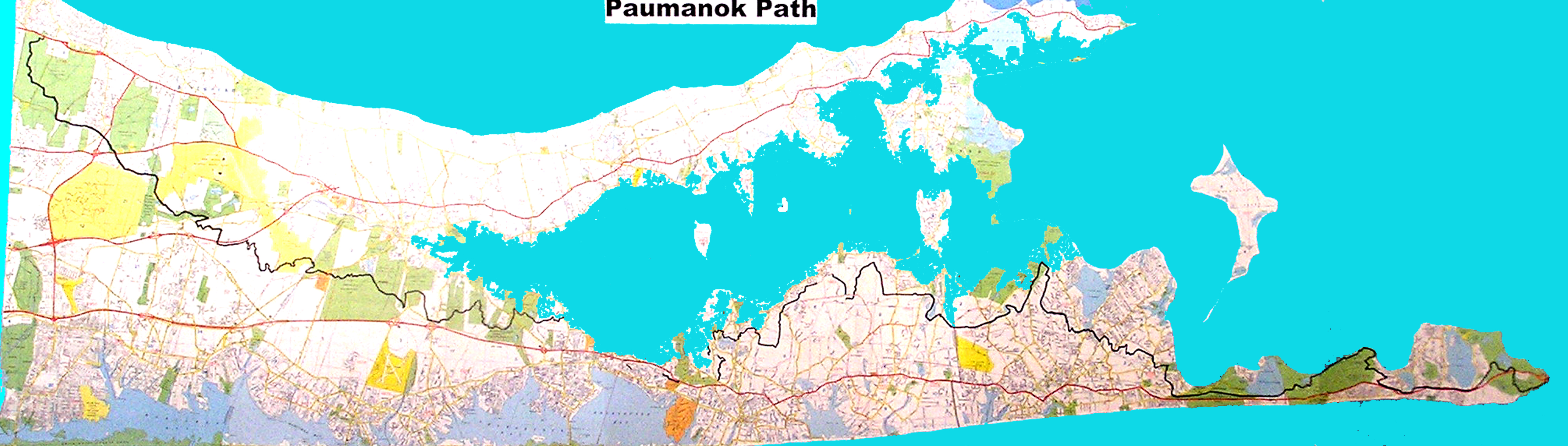
The Paumanok Path is a 125-mile long recreational trail that stretches from Rocky Point to Montauk Point. This path ties into many other trails and forms the backbone of Suffolk County’s trail system. In April 2016 Southampton Trails Preservation Society closed the last gap in the trail’s route.
The path is home to globally rare natural communities; glacial kettles and erratics; rolling hills with panoramic vistas; parabolic dunes; coastal plain ponds; enchanting beech forests; laurel woods in bloom; fresh water marsh habitats; spectacular vistas of the Peconic Bay Estuary and tidal marshes; white Atlantic cedar swamps; dwarf pines, pitcher plants; painted turtles; fields of reindeer lichen; maritime grasslands; harbor seals; harrier hawks; olive hairstreak butterflies; cedar waxwings and more. The Paumanok Path winds through Long Island’s most scenic and ecologically significant open spaces.
Much of the path travels over areas of great importance for groundwater recharge. More than anything else it was the enlightened initiative to protect Long Island’s drinking water that determined where the Paumanok Path would be routed. It is no coincidence that when you hike the Paumanok Path you encounter several series of beautiful coastal plain ponds. These self-cleaning reservoirs supply pristine water to the aquifers of the Island.
This Paumanok Path is situated in one of the most densely populated areas in the United States. This means that it is easily accessible to many people. Long Island has a large tourist industry that will profit significantly when the trail is successfully completed and promoted. A recreation trail 125 miles long, close to ocean beaches and rivers, and having nearby amenities normally associated with a metropolitan environment, is a resource that will attract many local and visiting outdoor enthusiasts.
This trail will advance a healthy economy through the promotion of tourism, a leading industry in the region. There is an important link between the health of our environment and our local economy. People visit the Hamptons because of our natural open spaces and beautiful waterways. Residents and visitors should be invited to enjoy these resources year-round. By encouraging people to enjoy our resources, we promote an appreciation for them.
The Paumanok Path and other trails give people a chance to experience and appreciate the remaining unspoiled beauty of Long Island’s open fields, woodlands, and wetlands. To walk along the length of this unique trail is to experience the natural history of Long Island. It is also an education in the importance of preservation.
The development of this Path emanated from a cooperative effort among many groups, agencies and organizations. The Paumanok Path is the result of a vision shared and effectively implemented by four towns: Brookhaven, Riverhead, Southampton, andEast Hampton. Its corridor is managed by the New York State Department of Environmental Conservation, New York State Parks, Suffolk County Parks, The Pine Barrens Commission, The Nature Conservancy, The Peconic Land Trust, and several municipalities and private landowners. It is the product of the mutual efforts of National Park Service Rivers and Trails, Group for the East End, Long Island Sierra Club, Long Island Greenbelt Trail Conference, East Hampton Trails Preservation Society, and Southampton Trails Preservation Society.
Southampton’s Paumanok Path
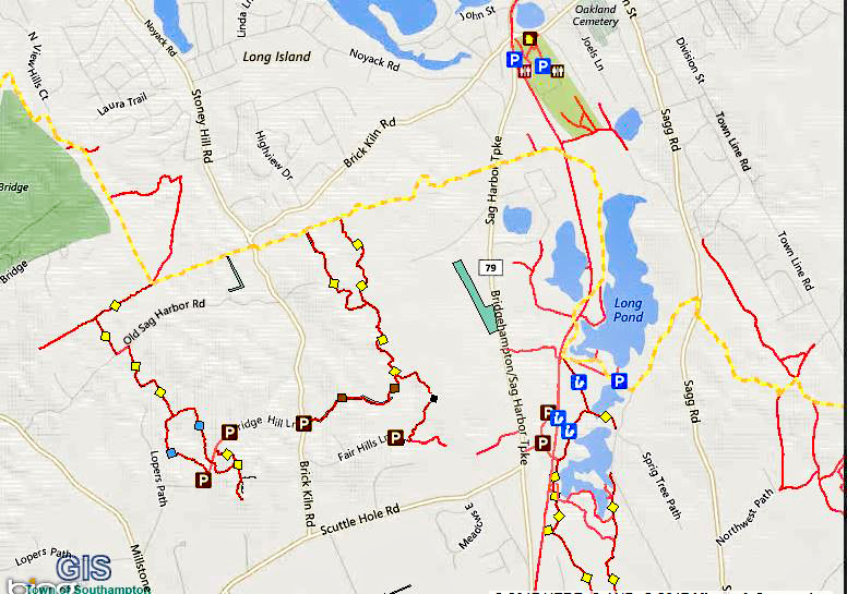
Southampton’s section of the Paumanok Path travels through many of the naturally beautiful places in this township. This is Southampton’s own natural heritage trail. The components of this trail exist today because of Southampton’s innovative and progressive Comprehensive Plan and because of the trails advocates and environmentalists who have advanced both the plan and the trail. As provided by the plan, completion of this path will help safeguard the visual and rural qualities of Southampton, provide recreational opportunities, and alternative modes of transportation. It runs through the magnificent Sarnoff Preserve, with its pygmy pitch pines and panoramic views, to Sears Bellows County Park with the huge Sears and Bellows Ponds, Hubbard Creek, and Red Creek Parks, then over the canal and into the maritime grasslands of the Nature Conservancy’s Shinnecock Hills, and north to Tuckahoe Hills with its freshwater wetlands and awesome view if the Peconic Estuary. The trail then continues through the enchanting Tuckahoe Swamp and into the spectacular Nature Conservancy’s Big Woods with the beech woods and views of Scallop Pond. From there, it runs through dense woods to Elliston Park with its views of Big Fresh Pond, and then continues over a dramatic knob and kettle topography. Continuing east, you will visit the surprisingly comely landfill overlook. Continue through dense woods where you visit majestic Split Rock and then it isn’t far to Southampton’s little gem, Laurel Valley County Park. From there sections of the old dirt road, Middle Line Highway, will take you (perhaps after a quick side trip to Trout Pond or Great Swamp) through a lovely and varied ecology to the chain of coastal plain ponds of the Long Pond Greenbelt, and finally into the pine-oak morainal forest between Sag Harbor and Sagaponack.
This wonderful trail will add to the quality of life for the citizens of Southampton both present and future, and it helps to forge an environmental and recreational vision for the region.